Monday, March 24, 2014

St Helena - A Rock in Atlantic Ocean

St Helena
A rock in the South Atlantic Ocean! (accessible only by boat) OK, so it's much bigger than a rock, its a volcanic tropical island that measures just about 16 x 8 km with a population of around 4,500 people. It is part of the British Indian Ocean Territory (BIOT) of Saint Helena, Ascension and Tristan da Cunha. It's also Britain's second-oldest remaining overseas territory after Bermuda.

We had set sail from Walvis Bay, Namibia on the 16th March 2014 and arrived in Jamestown, the capital of St Helena on the 24th March. Our passage here was fairly pleasant and calm. We picked up a yellow mooring in James Bay - No. 11 (S 15.55.561 W 05.43.581) for 3 days.

File:Topographic map of Saint Helena-en.svg
Map of St Helena
Jacob's Ladder

A prominent staircase of 699 steps, built in 1829 to connect Jamestown to the former fort on Ladder Hill. It was originally built as a funicular in the early 1800s, but the rails and cars were later removed due to termite damage on the sleepers. 

This left the stairs in place, which became a tourist attraction connecting Jamestown and the suburb of Half Tree Hollow at the top of the hill. People from all over the world come to take part in the yearly "Festival of Running", which is a timed run up the Jacob's Ladder. Below is a photo of my tanned feet at the top of the stairs. My legs were wobbly from the climb. (Updated: As of 2016, the record time to ascend the stairs is 5 minutes, 16.78 seconds). I was no where close to that!

Jacob's Ladder & my tanned feet
View of Jamestown from the top of the hill

Houses at the top of the hill

I was delighted to find on display a uniface coin from Penang, Malaysia in the St Helena Museum, which is situated at the foot of the Jacob's Ladder.

A piece of Malaysia at the Museum
St Helena Currency is fixed to the British Pound (£1 SHP = £1 GBP)

Possibly the longest signage for No Parking
Spot Napolean
St Helena Flag
Birdie in St Helena
Alex untangling the mooring
St Helena Stamp
Here we met Allan & Ursula on S/Y Windward from South Africa. We also topped up our provisions for the passage across the Atlantic ocean. This is not a great place for provisioning but we always make do with what we have. 


Read More »

Wednesday, March 12, 2014

Fish Canyon River, Namibia

Fish River Canyon

The second largest canyon in the world and largest in Africa/Southern Hemisphere. It features a gigantic ravine, in total about 100 miles (160 km) long, up to 27 km wide and in places almost 550 meters deep.

On our way to Fish River Canyon we had a flat tire and found a dead bird on the car
Spotted some wild life
Made a stop at Canon Roadhouse
A privately owned lodge about 25 km away from Fish River Canyon. A charming lodge decorated with old car parts found in the region.
 
Nice old cars


Our wheel flew off!! Just like in the movies, I ran after the wheel like a fox after a rabbit!

Read More »

Tuesday, March 11, 2014

Hammerstein: Up Close & Personal with Cheetahs

An amazing experience - up close & personal with Oscar and Wilde, 2 adorable Cheetahs at Hammerstein Lodge in Namibia.
Oscar - The Male
Wilde - The Female
A selfie with Oscar
Alex's arm
Fiesty Caracal
More of Oscar
So Adorable
Read More »

Monday, March 10, 2014

Sossusvlei, Namibia


Deadvlei
Sossusvlei is located in the southern part of the Namib Desert, in the Namib-Naukluft National Park of Namibia. These dunes are among the highest in the world. The tallest sand dune in Sossusvlei is 'Big Daddy' at 1066 ft/325 m.

It was about 380km drive from Walvis Bay. We spent 2 days here. Driving back and forth from our lodge in Hammerstein which is about 104km away. The long drive was absolutely worth it.
 

Amazing views - love the contour and shadows of the sand dunes


The sand here is about is 5 million years old, its so soft and fine that I had to take my shoes off as they just kept getting filled in. I kept my socks on though, because the sand gets quite hot at some spots.


Read More »

Sunday, March 9, 2014

Walvis Bay, Namibia

The passage from Cape Town, South Africa to Walvis Bay, Namibia was one of the coldest I've ever experienced. We departed V&A Waterfront in the early hours on 4th March 2014 and arrived on 8th March, covering 647 nautical miles. It was a pleasant sail as we had constant winds from the South-Southwest.

As we approached Walvis Bay, a large bird landed on Raptor. At first we were very careful not to spook it. Quietly taking photos of it behind the side panels. But it was so brave and friendly, it hopped towards us and perched itself on one of the winches in the cockpit.

Later we noticed a charter catamaran feeding these birds with fish to entertain their guests! I guess it thought we were one of them {sorry birdie, no num num here}.

So cold! All layered up

We anchored in the bay (S 22.57.236 E 14.28.935) for 8 days.

Every morning we'd find a few of these cuties on the transom

View from Walvis Bay Yacht Club
It was a busy and eventful week! We would've stayed longer if we weren't rushing to catch a flight from Brazil in April. 

To summarize our road trip, we drove from Walvis Bay to Hammerstein via Swakopmund and Solitaire. We stayed in Hammerstein Lodge for 3 nights where we had the opportunity to get close and personal with 2 lovely cheetahs. From there we drove to Sossusvlei, one of the highest sand dunes in the world. We drove back to Hammerstein for the night and back to Sossusvlei again the next day, before heading to Fish River Canyon via Maltahohe, Keetmanshoop and Grunau. 

On our way to Fish River Canyon, we had a flat tire and found a dead bird on the car. Later that day, the 2W gear box died and finally in the evening, the back wheel of our 4x4 rental car flew off. Stranded at the Fish River Canyon, we were fortunate enough to arrange for a last minute accommodation at Grunau and even convinced the owner to pick us up (a 212km drive return). 

He sent his two sons. One drove like a maniac speeding pretty much the whole way while the other held a bright torch to watch out for wild life. There was no doubt they were skilled and experienced drivers of the night. But a couple of times, I felt my heart fly out of my chest when we suddenly slowed down as Springbok antelopes dart across the road. Nevertheless, we were extremely grateful for the ride and roof over our heads that night.

The next day the car rental company arranged bus tickets for us from Grunau to Walvis Bay (approximately 1,053 km) via Keetmanshoop, Windhoek, Okahandja and Swakopmund.  

Route Distance: Walvis Bay -(41.6 km)- Swakopmund -(261 km)- Solitaire -(128 km)- Hammerstein -(104 km)- Sossusvlei -(104 km)- Hammerstein -(104 km)- Sossusvlei -(198 km)- Maltahohe -(283 km)- Keetmanshoop -(164 km)- Grunau -(106 km)- Fish River Canyon -(106 km)- Grunau -(164km)- Keetmanshoop -(498 km)- Windhoek -(72 km)- Okahandja -(281 km)- Swakopmund -(41.6 km)- Walvis Bay.

A total of 2,656.2 km (approximately). Longest distance road trip ever in 5 days!

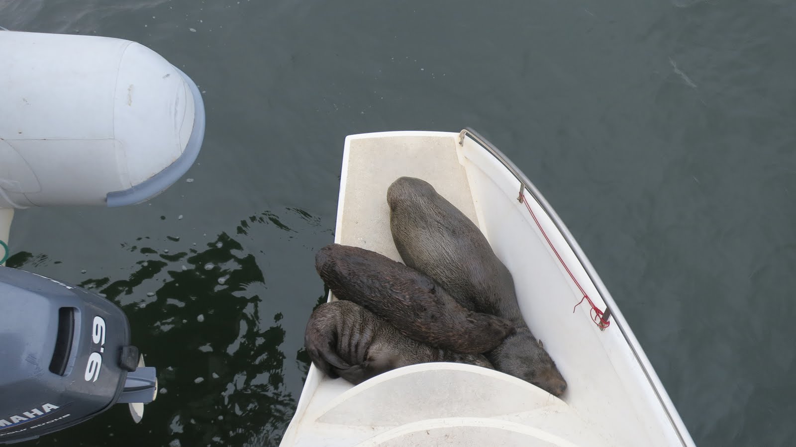
On our way back to Raptor, we spotted at least 8 Cape Fur seals on board. It appears they decided to boat sit for us while we were away. Unfortunately these uninvited guests only left dark brown stains, lots of fur and dried greyish poop for us to clean. 😆

Big lunch before at Anchors (Walvis Bay) before our voyage to St Helena
Missed out on the North but will be back someday for Etosha! Goodbye Namibia!

Oh, and we tried our best to get a refund on the car rental, as we did not get to use it for the entire rental period. But once we left Namibia, we did not hear from them again.. 

Read More »

Tuesday, February 18, 2014

Things To Do in Cape Town, South Africa

View of Table Mountain from Lion's Head
Cape Town is one of my favourite cities in the world. It's a beautiful blend of the coast, the mountains and the city. It's located on the shore of Table Bay, on the western coast of South Africa. It's the second most populous city after Johannesburg. It's safe, everything is reasonably priced and there's so much to see and do!

View of Lion's Head from Table Mountain
Even though we were berthed at Hout Bay, we caught the public bus into Cape Town frequently. The bus route goes along the coast which made it a nice and scenic ride.

We also hired a car for several days to visit Stellenbosch, Simon's Town as well as Table Mountain, Lion's Head in Cape Town.

Table Mountain is a flat-topped mountain forming a prominent landmark overlooking Cape Town. The main feature of Table Mountain is the level plateau approximately 3 kilometres from side to side, edged by impressive cliffs.

We hiked up via Platteklip Gorge to Maclears Beacon, then to the Upper Cable Station and back down under the cables to the Lower Cable Station. Do note the route under the cables (India Venster route) is not recommended for the faint hearted but if you're up to it, the view is spectacular! 

Adrena, Alex, Dror and I at the foot of Plattekilp George
Start of trail
The Plateau
The highest point on Table Mountain is towards the eastern end of the plateau and is marked by Maclear's Beacon, a stone cairn built in 1865 by Sir Thomas Maclear for trigonometrical survey. It is 1,086 metres (3,563 ft) above sea level, about 19 metres (62 ft) higher than the cable station at the western end of the plateau. 

Maclear's Beacon
About 45 mins walk from the Pletteklip George landing
View of the Hely-Hutchinson Reservoir
Feeling like I'm on top of the world
The dassie, or Rock Hyrax is surprisingly not a rodent (even though it looks like one) and the nearest living relative is the elephant!

Dassies are commonly spotted on Table mountain. They are well adapted to living on rocks and mountains; their feet have rubbery pads with sweat glands which allows them to grip and climb on steep rock surfaces.

We hiked back down via the India Venster route. This route is considered to be dangerous and classified as tough to difficult. It doesn't have a proper trail like the Platteklip route, but as long as you follow the yellow foot prints or spray paint marks you won't get lost. 

It's probably less scary climbing up than down
Beautiful view of Cape Town!
And Lion's Head
View from Lion's Head
Lion's Head is a mountain between Table Mountain and Signal Hill. It peaks at 669 metres (2,195 ft) above sea level. The peak forms part of a dramatic backdrop to the city of Cape Town.

Raptor Crew
All in one - where the ocean meets the city and the mountains

On 3rd March 2014, we departed Hout Bay and moved 20 nautical miles to V&A Waterfront Marina which is accessed from Granger Bay through the Victoria and the Alfred Basins under the Swing Bridge in Cape Town to clear out. 

Heading to V&A Waterfront Marina
Swing Bridge
Unfortunately on our way in just under the swing bridge, we hit a piece of log. It broke our morse cable and took a piece out of our prop! We had to stay a night in the marina (S 33.54.498 E 18.25.099) to complete our repairs. 

Goodbye South Africa
We set off for Namibia the next day. 

Goodbye South Africa! 113 days here and we're glad to report we've seen the big 5, enjoyed the local food, arts & crafts markets, visited the vineyards, sailed around the Cape, climbed up & down Table Mountain, had sea lions for "pets" and even bought a vuvuzela!

These memories shall not be tainted by the experience we had with Immigration at the time of clearing out. According to their system, we had over stayed our visa. Even though we spent 2 whole days at Home Affairs, visited 2 different offices, submitted the application and even paid for the extension before our visa expired. All that, and still get fined?! 


They have a very strange system in which you do not get an immediate approval/rejection for the visa extension, sometimes they take up to 6 months to respond. In our case, because we departed South Africa before we received our approval, we were therefore flagged as over stayed. 

We may not agree with how things are run but we still enjoyed our stay. South Africa is definitely on our top 5 favourite destinations. 
Read More »